Monday, November 28, 2011

Welcome to the Jungle: Phra Phradaeng, Bangkok's "Green Lung"

While researching Bangkok's waterway transit, I came across some descriptions of this hidden world just across the river from southern Bangkok. I read that there were anacondas and other jungle creatures lurking beneath the raised concrete walkways that span this very undeveloped peninsula, and that it is a popular bike tour destination. SOLD.

It was actually kind of tricky to get there, as there isn't much in the way of indication on the maps as to where the piers are. There is even less information about the peninsula itself, as you'll see from my Google Maps route.

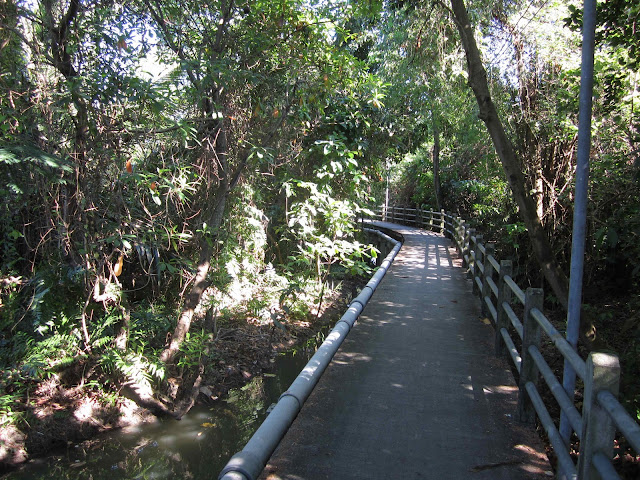
I didn't see any anacondas, but what I did see was a fascinating part of greater Bangkok that even many Bangkokians do not know about and have never visited. Much of the peninsula/island is inaccessible to four-wheeled vehicles, and as a result you end up traversing these raised concrete walkways that cross canals and marshland between palm plantations and straight up jungle. It's kind of a nature preserve but also a sleepy suburban community.

You can take your own bike (if you do, I recommend leaving from the Bang Na pier, which I've marked on the map) or rent one, if you take the skiff from the Khlong Toei pier, also marked more or less on the map. That's a location you'll probably have to ask your way to, as I did, unless you have access to a radically more detailed map than I had. Some pictures to give you an idea of what this place was like:

There are water buffaloes around that bend, I was soon to discover.
Romantic bicycle walkway shot
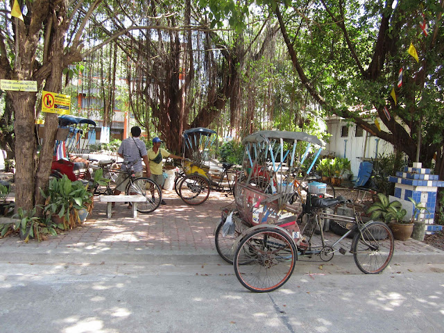
Rickshaw central, near the floating market and temple complex
Taking a break from ferrying people around the peninsula
King of all he can see
Leaving Phra Phradaeng on the boat to Bang Na
Map of the whole journey, with these images mapped and some extra ones:

Saturday, November 19, 2011

Riding north to Nonthaburi; ~14 mile loop

Today, as I was leaving my apartment with my bicycle, I ended up reflecting how sometimes knowing some Thai but not enough makes me tell little white lies. I was carrying my bike down the stairs, and the condo maid, who knew some details of my itinerary last weekend, asked me if I was going to the Grand Palace again. I paused in consternation, unable to explain that I had no destination and was going to make a loop in a general northwest direction. I sat there for a second trying to think of the various things I knew how to say, and none of them really worked. So I gave up. Yes, I'm going to the Grand Palace again.

But I didn't go there. This ride took me west and north, to Nonthaburi area, which is a suburb of Bangkok. Highlights include a friendly but stimulating mini alleycat race with a Thai rider I crossed paths with, finding a commuter railway station that might be a portal to awesome later, and a nice canalside walking park. And, as always, learning more about the roads that I can take to get around town, and which to recommend and disrecommend. Recommend: Pradhipat/Thanon Thahan, Thanon Pracha Cheun. Disrecommend: Thanon Krung Thep-Nonthaburi. I got some decent photos today, so click through the pins to see what I saw:)

Saturday, November 12, 2011

Exploring Bangkok just east of the Chao Praya, and trying to understand how sois connect

Today, I rode out west and south towards the palace again, taking a slightly different route that kept me off Phahonyothin and away from the skytrain pretty much altogether. The thing about being near or directly under the skytrain on one of those main thoroughfares is that it is dark, oppressive, loud, and pollution gets trapped in the air between the road and the raised track. Oh, and the devil lives there.

I found myself on a military base while trying to work out a soi route on the last bit to keep off the main road, which was interesting. Soldiers everywhere, but no one seemed to do more than look at me askance and with curiosity.

No pictures today; I was focused on riding. So I have comments about relative rideability of the roads, instead. :)

First ride map: Bangkok Flood Scouting-Banglamphu, Grand Palace, Lat Phrao, Phahonyothin

This is a map of actually two rides that I did, one on November 5, and then a second on November 6th. I have all kinds of photos embedded into the map, so you can see what you would be riding past if you did this. Day one was mostly east bound and back on some large arterials; day two was a more pleasant and scenic ride to the river and the Grand Palace.

View Bangkok flood bike scouting in a larger map Pier on the overflowing Chao Praya:


The most famous Khaosan Road, photographed from Samsen Road: